Category 3 Hurricane Erick Is Already in Oaxaca! The Major Hurricane Makes Landfall, and the Coast Feels Its Fury
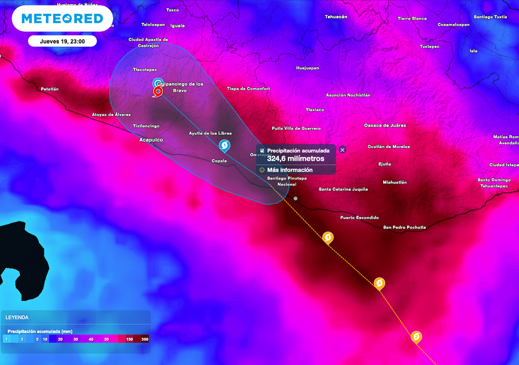
Oaxaca, Mexico, has been hit near Santiago Pinotepa Nacional by Category 3 Hurricane Erick, with wind gusts of over 250 km/h and 10-meter waves, generating extraordinary rainfall of over 250 mm.

"Erick" made landfall as a major Category 3 hurricane at 5:30 a.m., moving northwest. The broad circulation is producing extraordinary rainfall, intense wind gusts, and high surf in Chiapas, Oaxaca, and Guerrero.
According to the National Hurricane Center (NHC) and Mexico’s National Meteorological Service (SMN/CONAGUA), the center of major Hurricane Erick is currently located over the western portion of Oaxaca. It is expected to weaken during the morning as it moves inland over western Oaxaca and eastern Guerrero. However, torrential to extraordinary rainfall will continue in these states.
Over the next 12 hours, sustained winds of 180 to 200 km/h with gusts over 220 km/h are expected along the coasts of Oaxaca and eastern Guerrero, and sustained winds of 60 to 80 km/h with gusts of 100 to 120 km/h in coastal Chiapas. The system will weaken throughout the day.
In addition, waves of 8 to 10 meters are expected on the coasts of Oaxaca and Guerrero, 5 to 6 meters along the Chiapas coast, and storm surge of 3 to 4 meters on the coast of Oaxaca.

Major Hurricane Erick Dangerously Swirls Over Land in Oaxaca
"Erick" is located at 16.3°N, 98.3°W, about 30 km east of Puerto Escondido, Oaxaca, and 30 km east of Punta Maldonado, Guerrero.
It is moving northwest at 15 km/h, with maximum sustained winds of 205 km/h and gusts up to 250 km/h. Minimum central pressure is 950 millibars.
Three Zones Under Alert and Watch for Cyclonic Effects
- Hurricane warning zone from Acapulco, Guerrero to Puerto Ángel, Oaxaca.
- Hurricane watch zone from west of Acapulco to Técpan de Galeana, Guerrero.
- Tropical storm warning zone from east of Puerto Ángel to Salina Cruz, Oaxaca.
- Tropical storm warning zone from west of Acapulco to Técpan de Galeana, Guerrero.
Forecast Track for Major Hurricane Erick
Over the next few hours, "Erick" is expected to move dangerously close to eastern Guerrero over land Thursday morning, weakening significantly due to the Sierra Madre Occidental mountains. It will continue as a tropical storm in the coming hours.
In the medium-range forecast, the system is expected to weaken on Thursday night, continuing to deteriorate into a tropical depression by Friday and becoming remnants by Saturday near the state of Guerrero.

System-Associated Impacts
According to Meteored meteorological analysis, this tropical cyclone is expected to approach the national coast, bringing rain, strong gusts, high surf, and coastal flooding.
Rainfall may lead to overflowing rivers, lakes, and streams, along with landslides and mudslides in mountainous areas due to already saturated soils from recent rainfall in western and central Mexico. Flash flooding is also possible in urban areas.
Today's Recommendations
- If you detect lightning nearby, seek shelter in a dry room. Avoid being under trees, in sports fields, near water bodies, or swimming pools, as these areas are prone to lightning strikes.
- If rain persists for several days, there’s an increased risk of flash and river flooding. In such cases, NEVER attempt to cross a flooded street on foot or by vehicle. Also, avoid littering in streets or drains, as this can worsen urban flooding.
- Pay attention to wind strength. Strong gusts may cause flying debris or falling objects. Whirlwinds, dust devils, and tornadoes are also possible. If caught outside, immediately seek secure shelter.


